What Is Subsurface Utility Locating, and Why Is It Important?
Subsurface Utility Locating (SUL) is a crucial aspect of civil engineering and construction management. This specialised field involves identifying and mapping the underground utilities that may be present beneath construction sites. Understanding subsurface utilities is essential for planning, executing, and managing construction projects while minimizing risks. In this article, we will delve into the importance of subsurface utility locating, its processes, challenges, and future trends.
Understanding the concept of subsurface utility locating
Subsurface Utility Locating refers to the procedures involved in detecting and mapping utilities located underground. These utilities can include water, sewage, gas, electricity, telecommunications, and fibre-optic cables, which are critical to urban infrastructure. Accurate mapping of these utilities helps prevent disruptions during excavation and construction activities.
The development of SUL has brought to light the vital role that precise information on the location of underground utilities plays in project planning and safety. By understanding what lies beneath the ground, engineers and contractors can formulate better strategies for project execution, enhancing efficiency and safety on-site. Moreover, as urban areas continue to expand and develop, the complexity of underground utility networks increases, making the need for effective subsurface utility locating even more essential. It not only safeguards workers and the public but also protects the integrity of existing infrastructure, reducing the risk of costly damages and delays.
The science behind subsurface utility locating
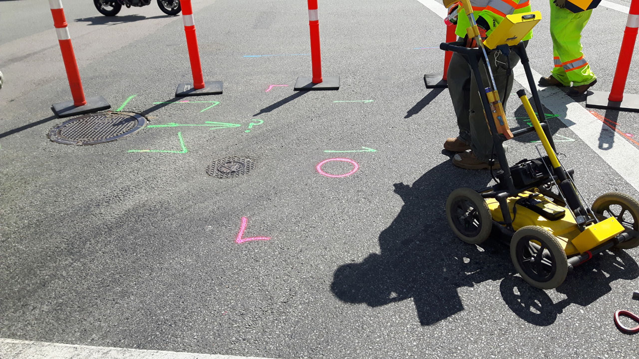
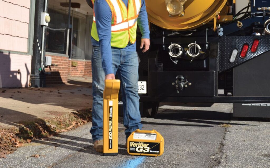
The science of subsurface utility locating employs various technologies and methodologies to detect and identify underground utilities accurately. Techniques such as ground-penetrating radar (GPR), electromagnetic induction, and acoustic location are commonly used in this field. Each method has its own advantages and limitations, and the choice often depends on soil conditions, types of utilities, and project requirements.
GPR, for example, uses radar pulses to image the subsurface, providing detailed information about the location and depth of utilities. Conversely, electromagnetic induction is effective for locating conductive materials, such as metallic pipes and cables. Together, these techniques enable professionals to create comprehensive maps that inform construction projects. Additionally, advancements in technology have led to the development of more sophisticated tools, such as 3D mapping systems, which allow for a more nuanced visualisation of underground utilities, facilitating better decision-making and planning. The integration of Geographic Information Systems (GIS) with utility locating data further enhances the ability to analyse and manage underground infrastructure, ensuring that all stakeholders have access to accurate and up-to-date information.
Key terms and definitions in subsurface utility locating
In the context of subsurface utility locating, several key terms are frequently used:
- Utility Conflict: A scenario where planned excavation work intersects with existing utilities, which can lead to potential hazards.
- Utility Mapping: The process of creating a detailed representation of all underground utilities based on collected data.
- As-Built Drawings: Documents that reflect the exact location of utilities after construction, vital for maintaining accurate records.
Familiarising oneself with these key terms enhances the understanding of subsurface utility locating and its practices, ultimately contributing to more effective communication among all stakeholders involved. Furthermore, the importance of maintaining accurate utility records cannot be overstated, as outdated or incorrect information can lead to serious consequences, including service interruptions and increased project costs. Regular updates and revisions to utility maps are essential, particularly in rapidly developing areas, ensuring that all parties are aware of the current state of underground infrastructure. This proactive approach not only mitigates risks but also fosters a culture of safety and accountability in construction practices.
The importance of subsurface utility locating
The significance of subsurface utility locating cannot be overstated. It plays a pivotal role in ensuring safety, reducing costs, and preventing delays in construction projects. By accurately identifying the location of underground utilities, construction firms can avoid costly mistakes and minimise disruption.
Ensuring safety during construction projects
Safety is the foremost concern in any construction activity. Unaware of the positioning of underground utilities, construction workers can accidentally strike gas lines or electrical cables, leading to hazardous situations, injuries, and costly repairs. Subsurface utility locating acts as a safeguard against these risks by identifying potential hazards early in the project.
Moreover, adherence to established regulations regarding utility locating helps maintain a safe working environment. Regulatory bodies often mandate utility locating before excavation, adding an extra layer of safety for workers and the general public alike. The importance of this compliance cannot be understated, as it not only protects workers but also minimises the risk of service interruptions for local residents and businesses. In many cases, utility strikes can lead to significant disruptions in service, affecting everything from water supply to internet connectivity, which can have a ripple effect on the community.
Reducing costs and preventing delays
In addition to safety, subsurface utility locating significantly contributes to cost reduction and project efficiency. By identifying utilities prior to excavation, contractors can plan accordingly, avoiding unexpected utility strikes that often lead to project delays and increased expenses.
Furthermore, the ability to resolve utility conflicts efficiently, thanks to pre-excavation knowledge, allows for smoother project execution. This results not only in time savings but also in cost savings for both contractors and clients. The financial implications of utility strikes can be staggering, often resulting in not just the immediate costs of repairs but also potential legal liabilities and penalties. By investing in thorough subsurface utility locating, companies can protect their bottom line while ensuring that projects remain on schedule. Additionally, this proactive approach fosters better relationships with clients and stakeholders, as it demonstrates a commitment to quality and responsibility throughout the construction process.
The process of subsurface utility locating
The process of subsurface utility locating involves multiple meticulously executed steps that ensure the accuracy and reliability of the data collected. This systematic approach is essential for the integrity of the entire locating process.
Initial site assessment and planning
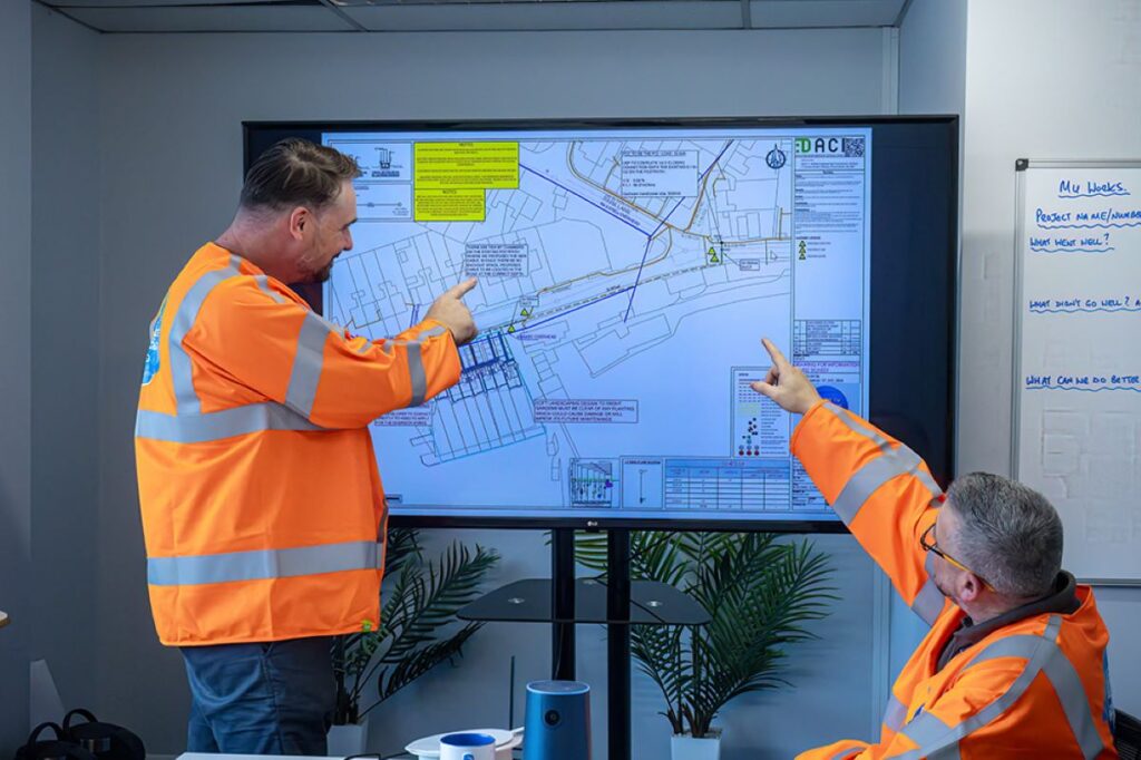
The initial phase in utility locating begins with a site assessment, where professionals evaluate the area, gather preliminary information, and plan the utility locating strategy. This includes reviewing existing utility maps, historical data, and any available as-built drawings.
During this phase, utility locating experts may also conduct interviews with local utility companies to gather additional insights that could affect the locating process, such as ongoing works or recent changes to utility layouts. Proper planning during this stage lays the groundwork for an efficient and effective locating effort. Furthermore, this stage often involves a thorough risk assessment, identifying potential hazards that may arise during the locating process. By understanding the local environment, including soil conditions and existing infrastructure, professionals can better anticipate challenges, ensuring that the project proceeds smoothly and safely.
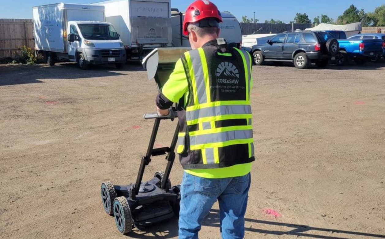
The role of technology in utility locating
Technology plays a vital role in enhancing the accuracy and effectiveness of subsurface utility locating. Modern advancements have led to the development of sophisticated locating equipment, such as multi-frequency GPR systems and real-time monitoring tools. These technologies provide precise and immediate data, which can be invaluable in complex projects.
Moreover, advancements in data analysis and integration software allow for the creation of comprehensive utility maps that facilitate better project planning. The synergy between technology and field expertise leads to improved efficiency in utility locating practices. Additionally, the incorporation of Geographic Information Systems (GIS) has revolutionised the way utility data is visualised and managed. By integrating various layers of information, GIS enables professionals to analyse spatial relationships and make informed decisions based on a holistic view of the subsurface environment. This not only enhances the accuracy of locating utilities but also aids in future maintenance and planning, ensuring that all stakeholders are well-informed throughout the project lifecycle. Visit https://astylistslife.com/how-utility-mapping-prevents-costly-excavation-mistakes/ to get how utility mapping prevents costly excavation mistakes.
Challenges and solutions in subsurface utility locating
Despite its importance, subsurface utility locating is not without challenges. Understanding these obstacles and exploring potential solutions is vital for success in this field.
Common obstacles in utility locating
Some common challenges faced in subsurface utility locating include the presence of conflicting utility records, inadequate historical data, and complicated ground conditions that affect locating accuracy. For instance, utilities can often become displaced or undocumented over time, making it difficult to ascertain their positions. Additionally, factors such as soil type, moisture content, and the density of existing infrastructure can complicate detection efforts.
Furthermore, the rapid urbanisation in many areas has led to an increase in the complexity of subsurface environments. As cities expand, new utilities are often installed in close proximity to existing ones, creating a tangled web of underground infrastructure. This not only heightens the risk of accidental damage during excavation but also complicates the task of accurately mapping these utilities. The lack of standardisation in utility mapping practices across different regions further exacerbates the issue, making it challenging for contractors and engineers to rely on utility maps that may vary significantly in quality and accuracy.
Innovative solutions for efficient utility locating
Innovation is key to overcoming the challenges of utility locating. Recently, there has been a significant push towards integrated utility management systems that utilise a combination of advanced technology and data analytics. These systems can reconcile historical data with real-time findings to create dynamic maps that more accurately reflect utility locations.
Moreover, collaboration among various stakeholders, including utility companies, construction firms, and regulatory agencies, fosters a shared understanding of existing utilities and leads to more comprehensive planning. Continuous research and development in this field are essential to improving locating methods and addressing emerging challenges. The adoption of technologies such as ground-penetrating radar (GPR) and electromagnetic induction has also shown promise in enhancing the accuracy of utility detection. These methods allow for non-invasive exploration of subsurface conditions, providing clearer insights into the layout of underground utilities while minimising disruption to the surrounding environment. As these technologies evolve, they hold the potential to revolutionise the way subsurface utilities are mapped and managed, paving the way for safer and more efficient construction practices.
The future of subsurface utility locating
The future of subsurface utility locating appears promising, with numerous trends and advancements on the horizon. As technology continues to evolve, so too will the practices surrounding utility locating.
Emerging trends in utility locating
One of the significant trends in subsurface utility locating is the increasing adoption of digitalisation and automation. Incorporating artificial intelligence and machine learning into utility locating processes can enhance data analysis and decision-making, enabling faster and more accurate detections.
Additionally, the use of drones equipped with advanced sensors is becoming more prevalent in the utility locating field. These unmanned aerial vehicles provide a unique vantage point, allowing for the efficient surveying of large areas, thereby streamlining the locating process.
The impact of regulatory changes on utility locating
As the industry evolves, so do regulations surrounding subsurface utility locating. Regulatory changes aim to establish better practices, improve safety protocols, and support efficient project execution. Staying abreast of these changes is crucial for professionals in the field, as compliance can significantly affect project timelines and overall success.
Ultimately, an evolving regulatory landscape will necessitate continual adaptation and innovation in utility locating methodologies, ensuring that this vital field keeps pace with the demands of modern infrastructure development.
In conclusion, subsurface utility locating is an indispensable aspect of construction and project management, ensuring safety, reducing costs, and facilitating efficient project execution. By understanding the process, challenges, and future trends associated with utility locating, professionals can leverage this critical information for successful project outcomes.